The Delta Corridors Plan would provide several major fish protection benefits
The DC Plan would nearly eliminate the entrainment of SJR fish at the CVP and SWP exports because all of the SJR flow and fish would be diverted into Old River and bypass the CVP and SWP exports unless the SJR flow at Vernalis was >10,000 cfs. This would allow all of the juvenile SJR fish to migrate down Old River to Franks Tract and the estuary without any losses at the CVP and SWP exports. This would greatly reduce the number of fish at the CVP and SWP fish facilities. The survival of juvenile SJR fish migrating to Chipps Island would likely be increased because the habitat conditions along the Old River corridor would provide more protection from predation and the migration times would be shorter than the migration times down the SJR. Tracking of acoustic-tagged fish would provide an accurate estimate of the juvenile SJR fish survival benefits.
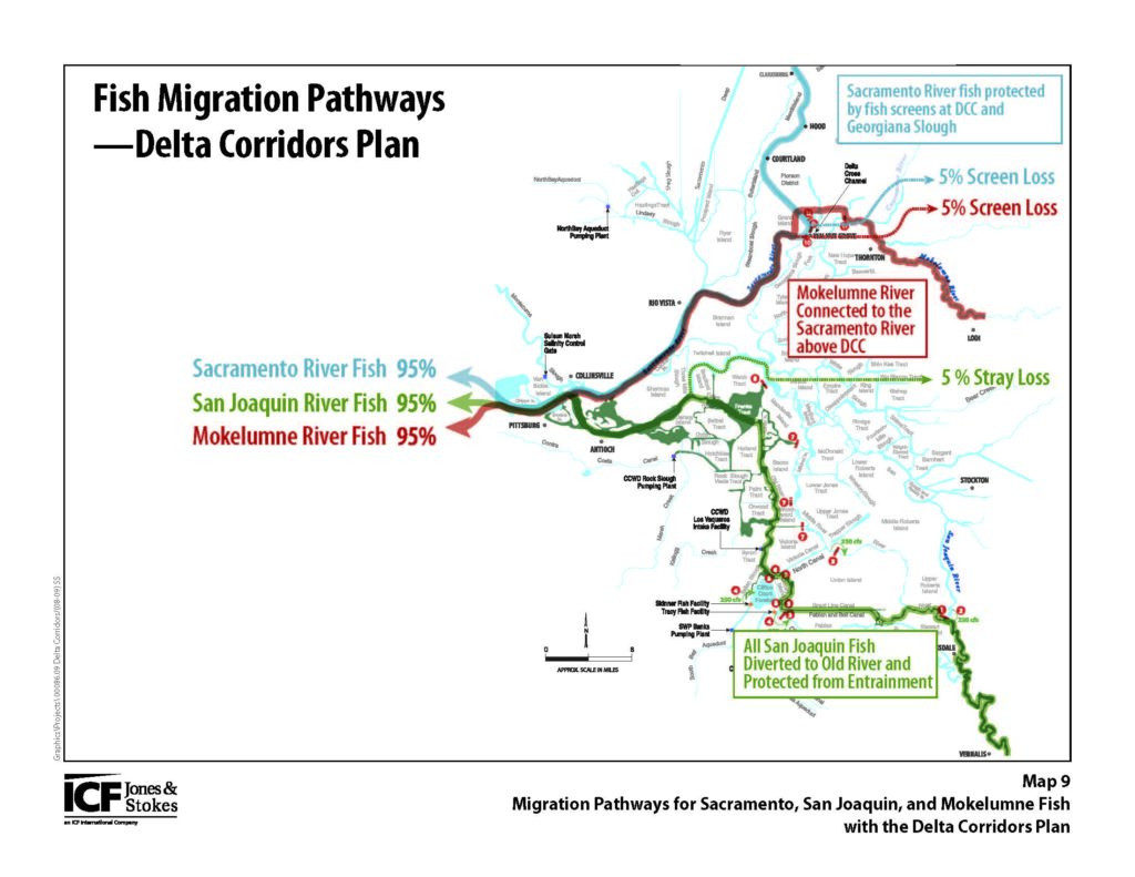
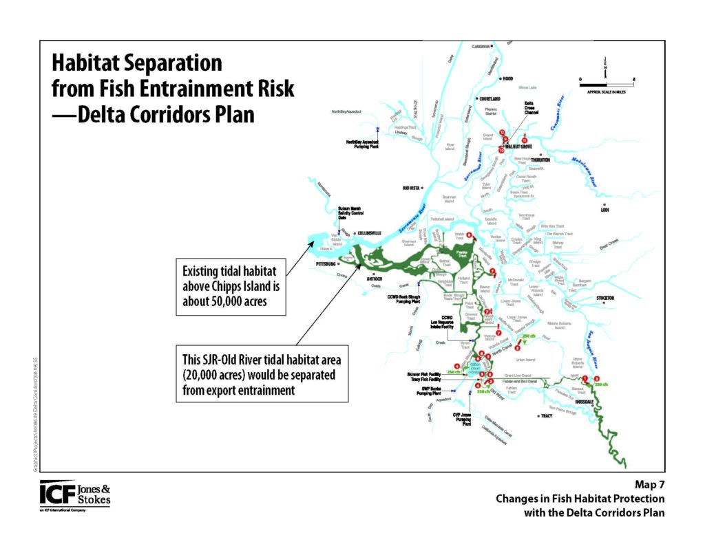
The DC Plan would nearly eliminate the entrainment of estuarine fish (e.g., delta smelt and longfin smelt) that migrate upstream into the lower SJR and Franks Tract and Old River habitat for spawning or rearing. The separation of the Old River and Middle River channels would provide much more protection from entrainment at the CVP and SWP exports for estuarine fish than the existing reversed OMR flow limits. Fish surveys in the lower SJR, Franks Tract and Old River would provide accurate estimates of the estuarine fish distribution and protection benefits.
The DC Plan would reduce the diversion of juvenile Sacramento River fish at the DCC and Georgiana Slough to the Mokelumne River and Middle River and to the CVP and SWP exports. The large fish-screens for the south gate of the DCC and for Georgiana Slough would protect about 40% of the Sacramento River migrating fish and increase the average survival from an estimated 64% with the DCC open or 72% with the DCC closed to an estimated 78% with fish-screens. Tracking of acoustic-tagged fish would provide an accurate estimate of the increased survival benefits for migrating juvenile Sacramento River fish.
The DC Plan would include a 2.25-mile long rock barrier along the south shore of CCF to provide a “salvage corridor” channel from the CCF intake gates to the Skinner fish salvage facility. The transport time for pumping of 5,000 cfs would be about 2 hours. This would minimize the exposure of smaller fish to predation loss in the CCF because the existing average travel time through CCF with pumping of 5,000 cfs is about 2.5 days. The fish channel would be constructed with swing-gates at the DCC intake and at the fish facility channel so that the benefits of the “salvage corridor” could be directly measured. The salvage corridor could be operated for a week and then closed for a week to identify the changes in fish salve counts with and without the salvage corridor. The salvage counts for juvenile fish is likely to double with the salvage corridor. This report describes some details about the CCF salvage corridor.
The DC Plan would include a 1.25-mile concrete wall that would divide the DCC and extend down Snodgrass Slough to Dead Horse Cut. The north gate of the DCC would be opened to allow fish passage to and from Snodgrass Slough and the Mokelumne River channels. Mokelumne River juvenile Chinook salmon and steelhead would migrate to the Sacramento River and avoid the high mortality from predation in the Mokelumne River and SJR channels. Sacramento River migrating juvenile fish could enter the tidal habitat of Snodgrass Slough for rearing. A 1,000-feet long and 15-feet high flat-panel wedge-wire fish screen would be constructed downstream along the Sacramento River levee to the Walnut Grove boat dock. A bottom wall and surface wall would reduce the number of fish encountering the screens and limit the sediment and floating debris at the screens. The south gate of the DCC would be automated to regulate the diversion flows during flood-tides to the fish-screen capacity of 5,000 cfs with a 0.33 ft/sec approach velocity. A submerged opening would be provided for upstream migrating adult fish that enter the Mokelumne River mouth. This report describes some details about the Mokelumne River connection to the Sacramento River at the DCC.
Estimating Fish Benefits with Daily Fish Tracking
Daily fish tracking methods could be used to evaluate the potential benefits of the DC Plan. Because the Delta inflows and exports vary substantially from day-to-day with major storm runoff events and because the migrations of fish are often triggered by these higher flow events, daily analyses of the fish movement patterns in the Delta channels are necessary to accurately evaluate the fractions of the migrating Sacramento River or San Joaquin River fish that likely move towards the CVP and SWP fish facilities at the south Delta pumping plants. While the water movement patterns can be measured at river and tidal flow monitoring stations, the fish movement and survival patterns are more difficult to evaluate. Daily fish tracking begins with estimates of the daily channel flows and initially assumes that fish are moving with the water at each channel junction. The results of acoustic fish tagging experiments (i.e., fish tracking) can be incorporated to identify fish selection fraction for each channel junction. Estimates of the fish survival in each pathway segment are needed to fully evaluate the likely benefits of physical fish screens at the DCC and Georgiana Slough.
Tracking of migrating fish through the Delta channel pathways requires estimates of the daily number of fish entering the Delta from each river or habitat. Because each fish species or Chinook salmon run have distinct seasonal spawning periods, each fish species or run enters the Delta with a specific seasonal pattern, although the daily migration abundance may also respond to storm events or other environmental conditions (e.g., turbidity or temperature). Acoustic tagging experiments can be used to determine the fish splits at channel junctions and the travel time and survival in each channel segment. Daily fish-tracking methods could be used to evaluate the fish survival benefits of Delta operations (e.g., DCC closure, reduced exports and increased outflow) and for evaluating the fish benefits of the DC Plan.
A good example of using daily flow and fish tracking methods in the Delta was the Environmental Water Account (EWA) that was explored with a daily Delta Operations Model that included the daily fish salvage counts from the CVP and SWP fish facilities. This report described the Delta operations modeling of the EWA and introduces some of the basic concepts about seasonal migration and spawning patterns and daily tracking of fish abundance (fish/taf) at the CVP and SWP fish Facilities.
This report describes the seasonal patterns of fish entrainment at the CVP and SWP fish protection (i.e. salvage) facilities. The fish protection facilities were constructed as the major mitigation measures to reduce the entrainment losses caused by export pumping.
Another example of daily fish tracking in the Delta was the evaluation of the fish protection benefits from the head of Old River spring barrier that was installed to reduce the diversion of SJR flow and fish towards the CVP and SWP exports. The daily fish counts from the Mossdale Kodiak trawls were compared to the daily fish salvage counts at the CVP and SWP fish facilities to determine the reduction in fish when the head of Old River barrier was installed. This report describes the fish tracking methods and the estimated fish protection benefits from the head of Old River barrier.
This report describes daily fish tracking methods for estimating fish protections that were likely achieved in 2011-2013 with the measures in the USFWS and NMFS biological opinions. The likely benefits from closing the DCC and from reducing exports during the January-June reversed OMR flow objectives were described and estimated.