The Delta Corridors Plan (DC Plan) was suggested to the Bay Delta Conservation Plan (BDCP) and Delta Vision stakeholder groups as an alternative Delta configuration to protect Delta fish and improve Delta export water quality. The DC Plan would allow water to be conveyed from the Sacramento River to the south Delta export pumps using the existing Delta channel network. The entire San Joaquin River (SJR) flow would be diverted into the head of Old River and be separated from the export pumping with a “river bridge” over a large box culvert in Victoria Canal to allow the SJR water to flow down Old River to Franks Tract. The major changes in the Delta channels and DC Plan features are:
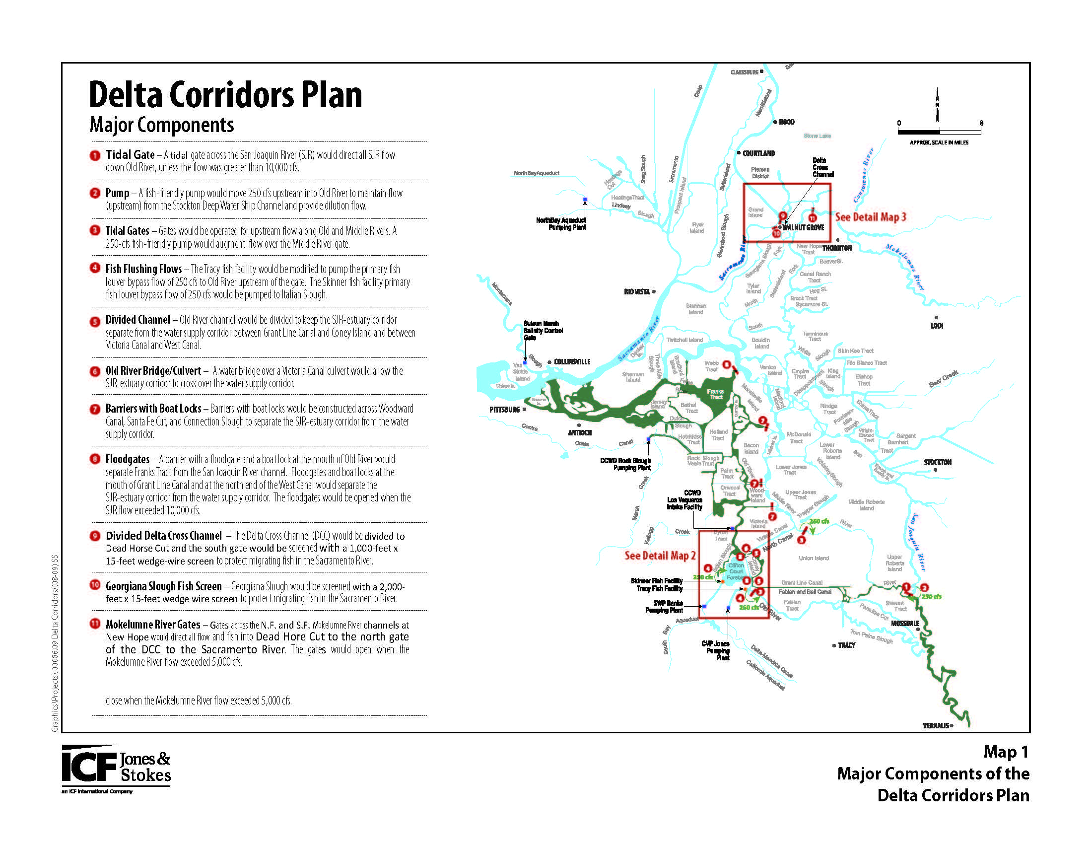
1. A tidal-gate barrier across the SJR just downstream of the head of Old River would be constructed; the tidal-gate would be opened when the SJR at Vernalis flow exceeds about 10,000 cubic feet per second (cfs). This would create a SJR–estuary corridor along Old River to eliminate the entrainment of migrating SJR fish and to separate about 25% of the Delta channel habitat area upstream of Chipps Island from entrainment risk at the SWP and CVP pumps.
2. A fish-friendly low-head pump with a capacity of about 250 cfs would provide a dilution flow from the Stockton Deep Water Ship Channel (DWSC) with the Stockton treated wastewater (50 cfs) into the head of Old River near Lathrop.
3. Tidal-gates as planned for the South Delta Improvements Program (SDIP) on Old River upstream of the DMC and on Middle River upstream of Victoria Canal would be constructed and operated for upstream circulation flows.
4. The Tracy fish facility would be modified to divert the primary fish louvers (i.e., screens) bypass flow of 250 cfs to Old River upstream of the tidal gate. The Skinner fish facility would be modified to divert the primary fish louver bypass flow of 250 cfs to Italian Slough. This would improve the survival of fish separated with the primary louvers at each fish facility, by releasing these fish to the SJR-estuary corridor and avoiding fish losses from holding, handling, trucking, and release operations.
5. A 2.25–mile-long rock-wall levee could be constructed along the southern portion of the Clifton Court Forebay (CCF) to connect the intake gates to the salvage facility with a salvage corridor. The salvage corridor would have a cross-section of about 2,500 square feet with a top width of about 200 feet and average depth of 12.5 feet to allow the maximum pumping flow of about 10,000 cfs to flow directly from the intake gates to the Skinner fish facility trash rack. A maximum velocity of about 4 ft/sec would transport fish to the salvage facility in less than an hour. The transport time for pumping of 5,000 cfs would be about 2 hours. This would minimize the exposure of smaller fish to predation loss in the CCF because the existing average travel time through CCF with pumping of 5,000 cfs is about 2.5 days.
6. Old River would be divided at two locations with wall structures (between Fabian Tract and Coney Island and between Victoria Canal and West Canal) to allow the SJR water to flow down Old River on the east side of Coney Island and to allow the water supply corridor water to flow from Victoria Canal to West Canal and to the CCF gates and the DMC intake.
7. A river bridge and box culvert would be constructed on Old River at the north end of Coney Island to allow the SJR water to flow over large box culverts from Victoria Canal to West Canal and continue down Old River to Franks Tract and the estuary. The water supply would flow under the Old River river bridge in the large box culverts from Victoria Canal to West Canal.
8. Rock barriers or concrete walls with boat locks would be constructed on Woodward Canal, Santa Fe Canal, and Connection Slough. These barriers would separate the water supply corridor in Middle River from the SJR–estuary corridor in Old River. The barriers or walls would be located at the east of the channels end to increase fish habitat. A rock barrier or wall with a boat lock and floodgate would be placed across the mouth of Old River, separating Franks Tract from the SJR channel. This would fully isolate the Franks Tract and Old River aquatic habitat from CVP and SWP pumping entrainment risk.
9. The Delta Cross Channel (DCC) would separated with a wall that would extend down Snodgrass Slough to Dead Horse Cut to allow migrating juvenile Mokelumne River fish to reach the Sacramento River through the north DCC gate. Diversions from the Sacramento River through the south DCC gate would flow through a large 1,000 ft long and 15-ft high fish-screen. The flow would be controlled by an operable DCC gate to maintain an approach velocity of less than 0.25 ft/sec.
10. The Georgiana Slough diversion flow would be screened to separate the migrating Sacramento River fish from the water supply diversions. The Georgiana Slough fish screen would be about 2,000 ft long (1,000 ft upstream and 1,000 ft downstream) and 15 ft high. A bottom wall and surface wall would reduce the number of fish encountering the screens and limit the sediment and floating debris at the screens. The surface wall also would protect boaters from any surface currents caused by the diversions. Boat locks or passage openings would be provided at both screens. These fish screens would be designed with baffles to maintain uniform approach velocities of less than 0.25 ft/sec to reduce fish impingement. Upstream migration of adult fish would be achieved with an open panel in the screens.
The simulated tidal hydraulics (i.e., tidal elevations and flows) were described and evaluated in a report (Jones & Stokes 2007) prepared for the South Delta Water Agency (SDWA) and Central Delta Water Agency (CDWA). The results demonstrated that full permitted exports (i.e., 4,600 cfs CVP and 6,680 cfs SWP) could be conveyed through the Middle River water supply corridor, after dredging about 7.5 million yards of sediment from shallow areas in Middle River and Victoria Canal. The dredging would maintain 3:1 (horizontal to vertical) slopes for channel stability to a depth of -25 feet mean sea level (msl).
This is the main report describing the DC Plan facilities and the potential fish protection benefits, the salinity reduction benefits and the water supply benefits that the DC Plan would provide.